Overview and Context / Key Statistics
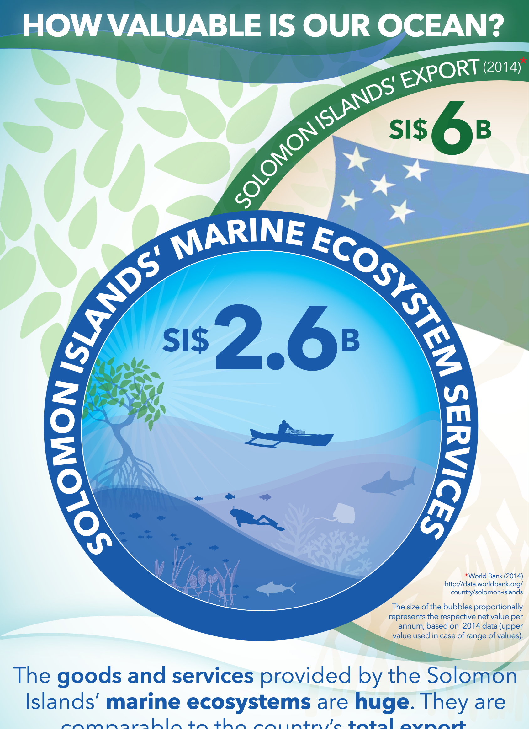
The Solomon Islands are part of the global centre of coral diversity, attributed to the islands’ wide habitat diversity. A total of 494 species of hard coral belonging to 76 genera have been recorded on Solomon Islands reefs, plus 9 possibly new species. This is the second highest species diversity in the world, second only to the Raja Ampat Islands region of eastern Indonesia. The MACBIO marine ecosystem service valuation estimated the value of marine ecosystem services of the Solomon Islands at USD 2.6 billion.
In 2006, reefs and coral communities of the Solomon Islands were in generally good condition. With the exception of some localized areas, impacts and reef degradation were low to moderate at most sites. Coral communities found in very sheltered inlets in the fjord-like coastlines are of particular interest. These communities are unique, had high species richness, usually high living coral cover, and in 2006 were generally in good health, with hard coral cover of between 35 and 45% (Turak 2006). Lau’alo Passage (northeast Malaita) with its extensive shallow reef areas and reticulate channels, seagrass meadows and artificial reef island villages, is an area of great ecological and cultural value and potential conservation interest (Turak, 2006).
Key Statistics For Solomon Islands Reefs
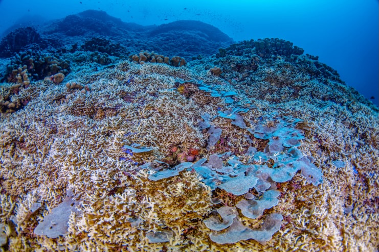
Largest Coral in the World Found in the Solomon Islands, 2024
Photo Credit: Manu San Félix, National Geographic Pristine Seas
Reef Condition and Ecological Status
Solomon Islands Temporal Trends in Benthic Cover
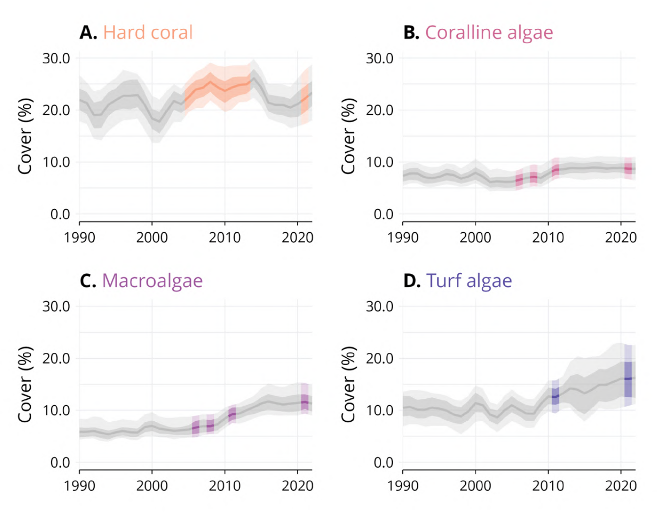
The following estimation of trends in the benthic cover of hard coral, coralline algae, macroalgae, and turf algae in Solomon Islands is provided in the 2025 Pacific GRCMN report and was achieved through the integration of 4 datasets, representing a total of 78 monitoring sites, on which 176 surveys were conducted between 2005 and 2021. To access reference of the datasets, please refer to Supplementary Table 1 in (Wicquart et al., 2025).
Solomon Islands Monitoring Sites and Datasets for Benthic Cover
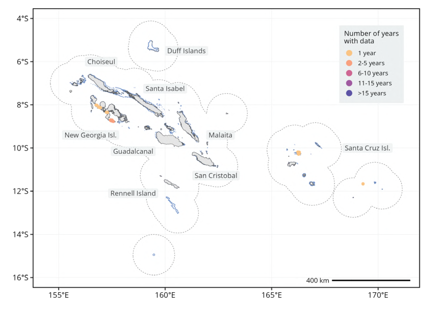
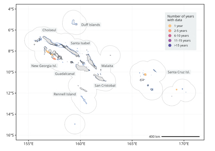
Spatio-temporal distribution of benthic cover monitoring sites across Solomon Islands. Sites that were monitored for the longest period of time are represented on top of the sites monitored for fewer years. The scale bar provides distance at the equator and may not accurately represent distance over the entire latitudinal range of the economic exclusive zone. Dashed polygons represent a 100 km buffer around coral reefs. Note that only land and coral reef buffers of the country or territory are represented, not those of adjacent countries and territories. The distribution of coral reefs is shown in light blue. (Wicquart et al., 2025)
Solomon Islands Benthic Cover Temporal Trends
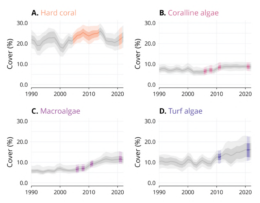
Modeled temporal trends for hard coral (A), coralline algae (B), macroalgae (C), and turf algae (D) cover from 1990 to 2022 in Solomon Islands. The bold line represents the estimated average cover, lighter and darker ribbons represent 95% and 80% confidence intervals, respectively. Gray areas represent periods where no observed data were available. (Wicquart et al., 2025)
Climate and Environmental Stressors
Coral reefs are threatened by climate and environmental stressors, including ocean warming, acidification, storms, pollution, overfishing, and sedimentation. These pressures cause bleaching, weaken corals, damage reef structures, promote algae and disease, reduce light, and ultimately lower reef resilience and recovery.
Cyclones
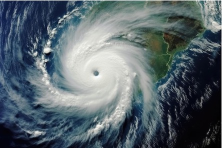
Cyclones are a recurring destructive disturbance in the Solomon Islands, bringing strong winds, heavy rain, and storm surges that damage coastal, terrestrial, and reef systems. Events such as Cyclone Namu (1996) and recent cyclones have caused flooding, infrastructure loss, and community displacement. On reefs, cyclones break corals through wave action and increase sediment runoff, which smothers corals and reduces water clarity. Repeated impacts can weaken reef resilience and heighten vulnerability to warming seas and ocean acidification (Nanau, 2017).
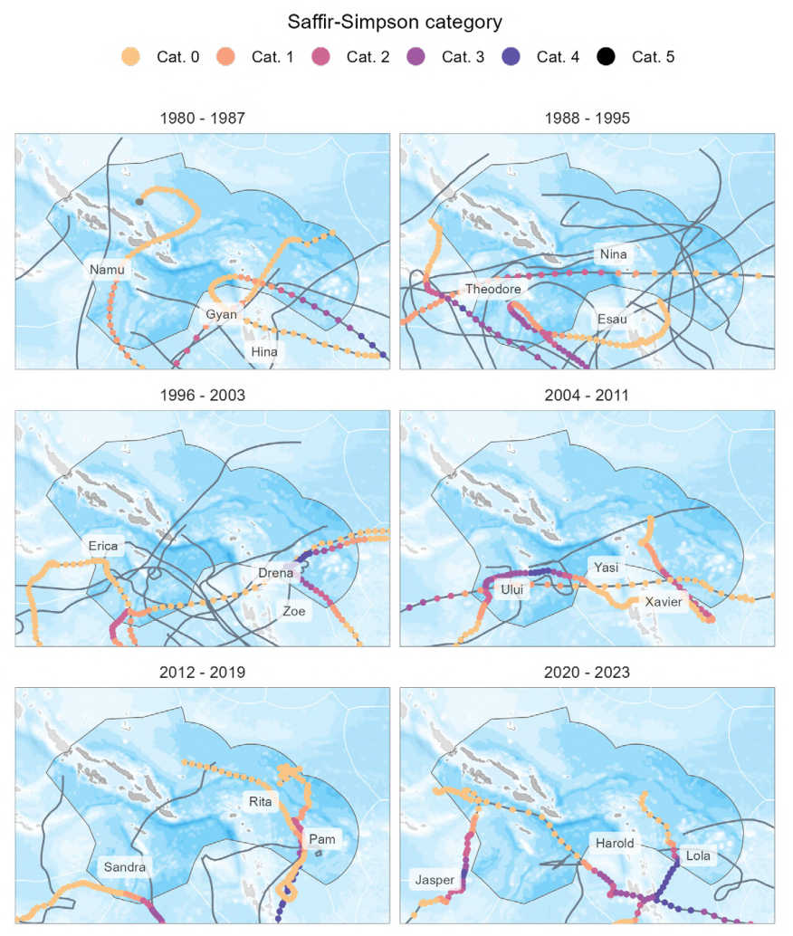
Maximum sustained wind speed of tropical storms passing within 100 km of a coral reef between 1980 and 2023 in Solomon Islands. Colors correspond to the cyclone’s Saffir-Simpson category along its entire track. However, the values of sustained wind speed are extracted from the nearest tropical storm position from a coral reef. For this reason, some sustained wind speed values are below the lower threshold of category 1 Saffir-Simpson scale (i.e. 119 km.h-1). Note that cyclones passing more than 100 km away from coral reefs of Solomon Islands are not represented, although they may have had an impact. Derived from IBTrACS data (https://www.ncei.noaa.gov/products/international-best-track-archive) for the GCRMN Pacific report (Wicquart et al., 2025)
Solomon Islands Cyclone Trajectories
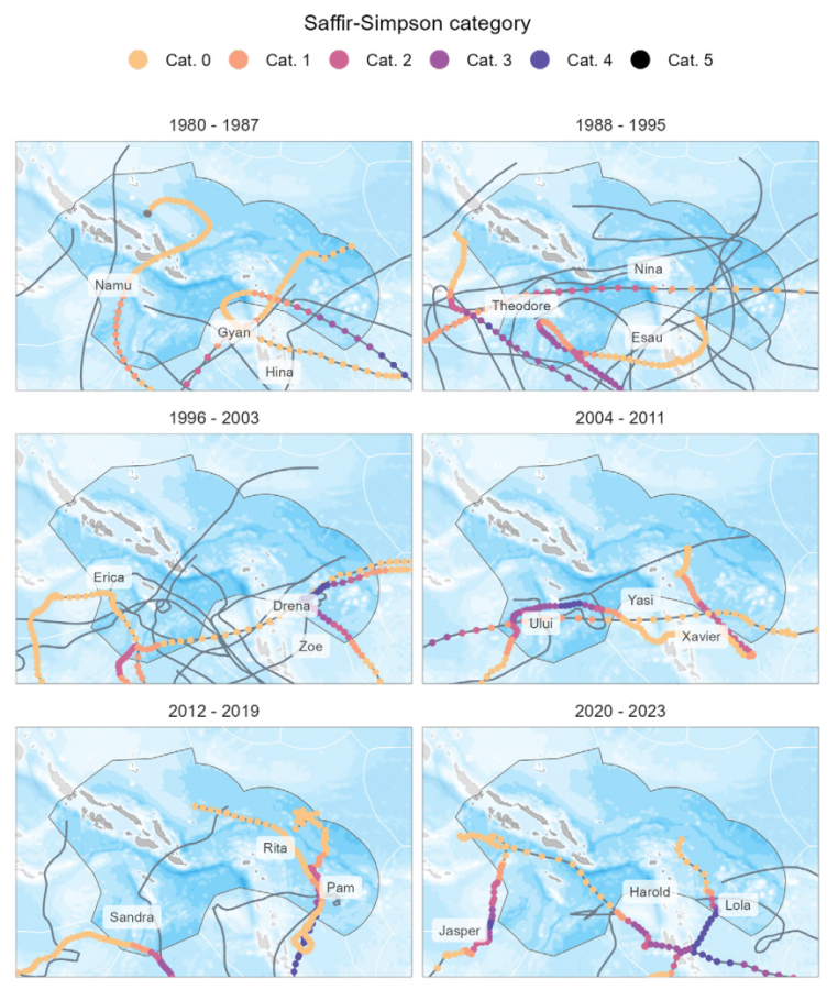
Trajectories of cyclones passing within 100 km of a coral reef between 1980 and 2023 in Solomon Islands. Points correspond to cyclone positions every 3 hours and are colored depending on the Saffir Simpson scale of the sustained wind speed. Grey points correspond to cyclone positions on which wind speed was not available. For readability, only the three most powerful cyclones are labeled and colored per time range (i.e. subplot). The trajectories of other cyclones are represented by gray lines only. (Wicquart et al., 2025)
Sedimentation and Eutrophication
Logging: Large-scale logging is a major driver of environmental degradation and coral reef decline in Solomon Islands. Over four decades, more than 12,000 km of poorly engineered roads have increased erosion and sediment runoff into rivers and coastal waters, reducing water quality and smothering reefs. Timber exports exceed sustainable limits by more than ten times, accelerating forest loss, while weak regulation and limited transparency persist across more than 100 operations. Although logging contributes about 15% of government revenue and 32% of foreign exchange earnings, benefits are uneven, creating social tensions and threatening rural livelihoods and food security. Overall, logging-related sedimentation, pollution, habitat damage, and ship groundings are considered the country’s primary coral reef threat (Van et al., 2020).
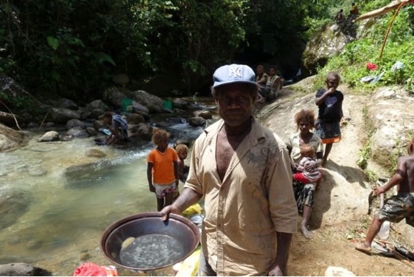
An artisanal miner from Nusuta village in Solomon Islands showing the gold produced from two to three hours work at the Charivunga river, Gold Ridge. Copyright Matthew Allen, February 2015 website; Money flows to casual gold diggers in Solomons | RNZ
Mining: Mining is promoted in Solomon Islands as logging declines, but it poses major environmental risks. Only Rennell’s bauxite mine is currently operating, while other projects face legal delays. Incidents such as the near-collapse of the Gold Ridge tailings dam highlight toxic pollution risks, and growing mining interest, combined with limited regulation, raises concerns about future environmental and social impacts (Van et al., 2020).
Wastewater: is a major coral reef stressor in Solomon Islands, especially near urban centres such as Honiara, Auki, and Gizo, where sewage treatment is absent. Poorly designed septic tanks, open defecation, and industrial wastewater—particularly from mining—pollute coastal waters, increasing coral disease and human health risks, though the full reef impacts remain unclear.
Disturbance and Event History
Located within the Pacific Ring of Fire, Solomon Islands is highly exposed to earthquakes, tsunamis, cyclones, and floods, which have repeatedly caused destruction and displacement. Key events include the 1976 earthquake, Cyclone Namu in 1996, the 2007 earthquake and tsunami that killed 52 people, the 2013 Santa Cruz tsunami that killed 10 people, and Tropical Cyclone Ita in 2014, which caused severe flooding, 22 deaths, and affected more than 50,000 people. Similar disasters across the Pacific, such as Cyclones Pam and Winston, highlight rising climate-related risks and the need for regional cooperation and global climate action.
In 2016–17, repeated heavy rainfall, floods, and tropical depressions damaged food gardens, water supplies, roads, bridges, and health services, especially in rural communities. Government and partner agencies supported recovery through assessments and emergency supplies while communities awaited restoration of food sources and basic services (Nanau, 2017).
Crown-of-thorns starfish (COTS) outbreaks and coral diseases are major biological reef disturbances. COTS rapidly consume live coral during outbreaks, while diseases weaken and kill corals, reducing recovery and contributing to long-term reef degradation.
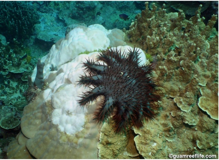
The Crown-of-Thorns Seastar. Photo courtesy of GuamReefLife.com and David Burdick.
Crown-of-thorns starfish (COTS) outbreaks: have caused significant coral mortality in parts of the Solomon Islands. High numbers have been linked to increased runoff from land, and outbreaks have been reported in areas such as Western Province and Temotu (Van et. Al., 2020).
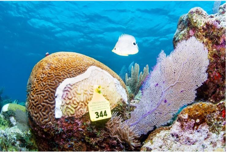
Monitoring the progress of coral disease. Photo courtesy: Antonio Busiello. A Coral Disease is Spreading Through World's Second-Largest Barrier Reef | Scuba Diving
Coral diseases: are an underreported but important cause of coral loss globally. In the Solomon Islands, there is limited information on their spread and impact, with few cases recorded in past surveys. However, coral diseases are known to increase with terrestrial runoff and sewage pollution, which raise harmful microorganisms in the water and contribute to reef degradation (Van et. Al., 2020).
Biodiversity and Ecosystem Function
Recent surveys documented six new coral records for Solomon Islands: Leptastrea bewickensis in the Three Sisters and Temotu, and Acropora glauca, Acropora macrostoma, Acropora scabra, Porites mayeri, and Porites negrosensis in Temotu. The known range of Goniastrea minuta was also extended to Temotu (Timmers et al., 2025).
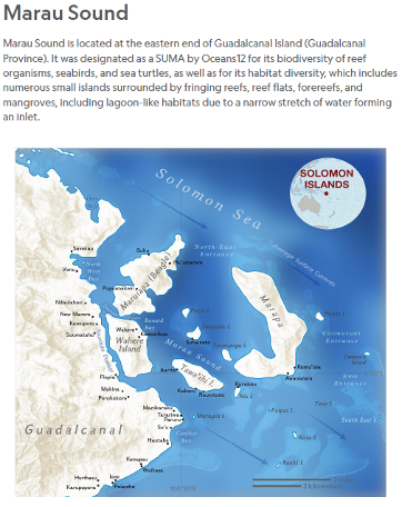
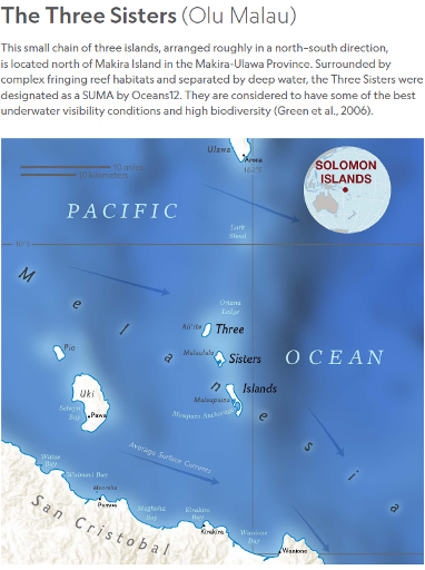
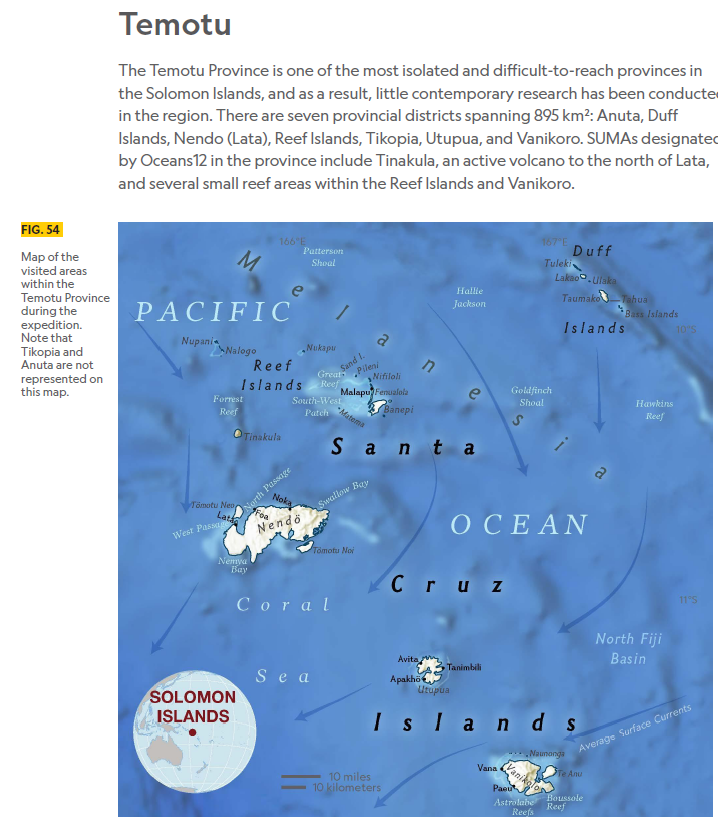
Pristine seas (Timmers et al., 2025) reported the surveys were done near Marau Sound, the Three Sisters and Temotu.
Corals: Survey teams recorded 98 coral species from 13 families in Marau Sound, 87 species from 13 families in the Three Sisters, and 247 species from 16 families in Temotu. Leptastrea bewickensis from the Three Sisters was confirmed as a new national coral record.
Algae: Surveys documented 39 algae species from 14 families in Marau, 30 species from 11 families in the Three Sisters, and 51 species from 15 families in Temotu.
Invertebrates: Marine invertebrate records included 26 taxa from 21 families in Marau and 24 taxa from 14 families in the Three Sisters.
Fish and sharks: Reef-associated fish surveys recorded 355 species from 35 families in both Marau and the Three Sisters, and 309 species from 36 families in Temotu. In Marau, the most species-rich families were wrasses, damselfish, butterflyfish, surgeonfish, and parrotfish. Two IUCN-listed species were observed in the Three Sisters: the Near Threatened butterflyfish Chaetodon trifascialis and the Vulnerable damselfish Amblyglyphidodon ternatensis.
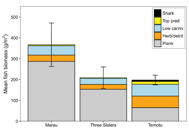
Reef Associated fish biomass at the survey sites (Timmers et al., 2025).
Benthic Condition: Around Marau, coral richness was high but coral cover was relatively low, averaging 16.3% across the stations and ranging from 1.6% to 43.2%. Shallow sites had higher coral cover (20.3%) than deeper sites (12.3%), while many reefs were dominated by algae (28.9%) or sediment and rubble (30.2%). Reef condition scores ranged from unhealthy to healthy, with an overall score of 73, indicating fair condition but a need for improvement.
In the Three Sisters, coral cover was also low, averaging 12.8% overall, with higher cover at 10 m (18.9%) than 20 m (6.1%) and station values ranging from 2.8% to 40.8%. Algae cover (19.8%) exceeded coral cover, and cyanobacteria—an indicator of reef stress—averaged 9.9%, with higher values near the inhabited islands of Malaupaina and Malaulalo than the uninhabited island of Aliite. However, high crustose coralline algae cover, averaging 25% overall and 39% in shallow areas, suggests potential for coral recruitment and recovery. At one station, the encrusting sponge Lamellodysidea herbacea dominated the benthos. Overall reef condition was fair, with three healthy and three unhealthy stations, including one very unhealthy site.
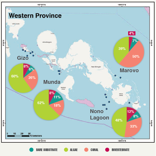
In the Western province, the Khaled Bin Sultan Living Ocean Foundation (KSLOF) surveyed sites near Gizo, Marovo, Munda, and Nono Lagoon. These areas had an average live coral cover ranging from 18-49% (Carlton et al., 2020)
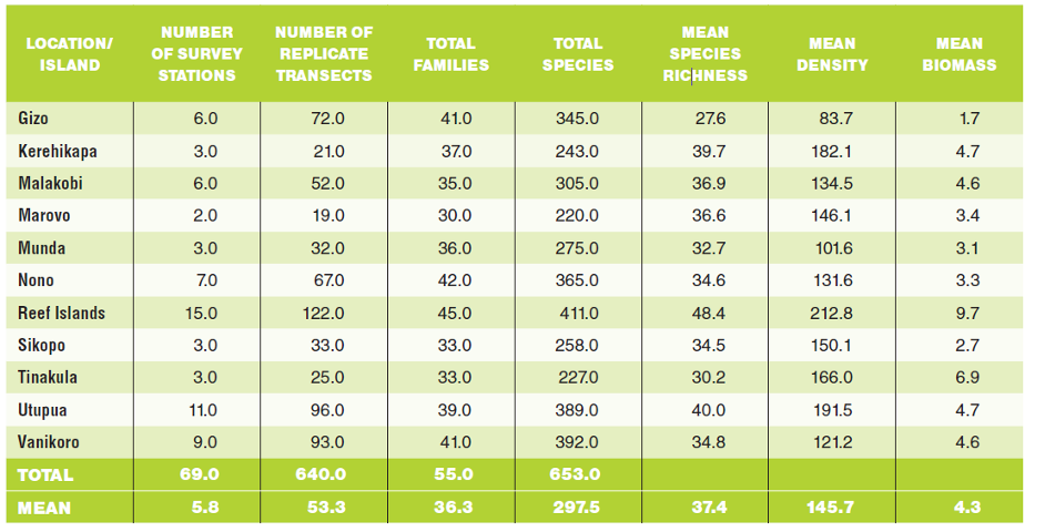
In total, 653 species from 55 different families were surveyed in the Solomon Islands during the research period (Carlton et al., 2020).
Connectivity and Genetics
eDNA is genetic material released into seawater by organisms and dispersed by currents, waves, and other processes. By filtering water samples and comparing extracted DNA with reference databases, researchers can detect marine biodiversity, including rare and cryptic.
Researchers from the 2024 Pristine Seas Expedition filtered 6 L of water at each of 18 sites: three in Marau, five in the Three Sisters, and 11 in Temotu. The analysis produced 604 distinct genetic groups, including 469 species across 81 families and 236 genera, among them 455 fish, four dolphins, Blainville’s beaked whale, the Critically Endangered scalloped hammerhead shark, and three ray species.
Most detected fish species were reef-associated (400 of 469; 85%), while 69 were from deeper or pelagic habitats, possibly reflecting residual DNA from migration, upwelling, or larval dispersal. Over 275 species were not recorded by divers or cameras, highlighting eDNA’s strength in detecting rare or cryptic taxa such as gobies, blennies, and morays (Timmers et al., 2025).
Management and Protection
International conservation NGOs, including WWF, The Nature Conservancy, and FSPI[NR1] , have helped address environmental governance gaps in Solomon Islands through community-based marine management. Successful examples include the Tetepare Descendants’ Association in Western Province, community-conserved areas on Choiseul, and the Arnavon Community Marine Park on Isabel. However, these efforts remain concentrated in a few areas and often exclude heavily exploited or ecologically important reef systems. Although about 350 communities have joined fisheries management initiatives covering roughly 1,000 km², only 10–20% of locally managed marine areas continue after external support ends, and just 80–120 function across around 4,000 coastal communities. Scaling up will require longer-term funding, stronger civil society engagement, better coordination through platforms such as SILMMA, and broader partnerships with development NGOs, local organizations, churches, women’s groups, and fishers’ associations to support sustainable, ecosystem-based coral reef management.[NR2]
Legislative frameworks
The Environment Act (1998) is Solomon Islands’ main legal framework for coral reef protection, regulating development, pollution, and marine conservation. It requires Environmental Impact Assessments (EIAs) for activities such as logging, mining, tourism, and coastal development to prevent or reduce reef damage before approval. The Act also supports pollution control, marine protected areas, mangrove and reef conservation, community-based resource management, stronger monitoring, and regulation of harmful fishing and extractive activities. Its effectiveness, however, depends on enforcement capacity and implementation.
The Wildlife Protection and Management Act (1998) supports coral reef conservation by regulating marine species exports under CITES. It bans exports of vulnerable species such as marine turtles and anemone fish and controls trade in reef species including clams, pearl oysters, sea cucumbers, sandfish, and recently listed black and white teatfish. MECDM enforces the Act with fisheries, forestry, and customs authorities to protect marine biodiversity and ensure trade compliance.
The Maritime Safety and Administration Act (2009) helps protect reefs by regulating domestic shipping and preventing marine pollution, including oil spills and ballast water discharge. Aligned with MARPOL, it assigns SIMA responsibility for managing maritime activities and reducing pollution risks to coastal and reef ecosystems.
The Protected Areas Act (2010) allows ecologically important areas, including coral reefs, to be designated as protected areas; the Arnavon Community Marine Park was the first marine protected area declared under the Act. It supports community-based conservation, reef monitoring, ranger systems, and eco-tourism, but registering customary land requires management plans, landowner agreements, and governance structures. The process is complex, often reliant on external support, and less suited to small, locally managed marine areas with limited long-term funding.
The Biosecurity Act (2013) supports coral reef protection by aiming to prevent the introduction and spread of invasive species and diseases that can harm marine ecosystems. It is implemented by Biosecurity Solomon Islands, with a primary focus on agricultural threats, complemented by the National Strategy on Aquatic Biosecurity, which strengthens measures to manage aquatic diseases and invasive species affecting coastal and reef environments.
The Fisheries Management Act (2015) is key to coral reef protection in the Solomon Islands, promoting sustainable use and banning destructive fishing methods like dynamite, poison, and electric fishing. It empowers the Ministry of Fisheries and provincial governments to manage reef fisheries, establish protected areas, and support community-based management. The Act also protects biodiversity through size limits, bans on endangered species harvesting, and restrictions on shark fin trade and small-mesh nets. While it provides a strong legal framework, its effectiveness is limited by challenges in implementation, enforcement, and complex community management requirements
Risk, Resilience and Priority Areas
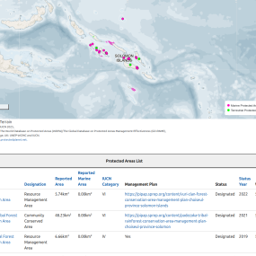
Solomon Islands has 94 protected areas, but overall protection is still low (about 0.11% marine and 2.39% land)[NR1] . It is highly biodiverse, with nearly 2,900 species and many key biodiversity areas. Pacific Islands Protected Areas Portal
Coral reefs are better protected (77%), and conservation is largely community-based Solomon Islands | PIPAP
Priority areas:
- The World Heritage Convention (1975) aims to identify and conserve cultural and natural sites of outstanding universal value through the recognition of World Heritage Sites by the United Nations Educational, Scientific and Cultural Organization (UNESCO).
- Evidence of resilience in Protected Areas: While overall reef health showed stress, areas like Nukapu in Temotu, a “No-Take Tabu” area, demonstrated significantly healthier fish populations, high coral cover, higher herbivore biomass, and more balanced trophic structures, showcasing the positive impact of local protection efforts.
Timmers et al.
Data, Methods, Resources and References
Denley, D., Metaxas, A. and Scheibling, R. (2020) ‘Subregional variation in cover and diversity of hard coral (Scleractinia) in the Western Province, Solomon Islands following an unprecedented global bleaching event’, PLoS ONE, 15(11), p. e0242153. Available at: https://doi.org/10.1371/journal.pone.0242153
Nanau, G. L. (2017). Solomon Islands. the contemporary pacific, 29(2), 354-361.
Timmers, M., Goodell, W., Kindinger, T., Mayorga, J., Thompson, C., Aram, D., Ballesteros, K., Brown, E., Barnaby, M., Friedlander, A., Inone, S., Kere, N., Otana, L., Posala, R., Pitakaka, P., Tepai, H., Young, L. and Sala, E. (2025) Solomon Islands: Scientific report from the 2024 National Geographic Pristine Seas Expedition. November 2025.
Toki, B. and Tobin, L. (2025) Pacific Coral Reef Monitoring Assessment. Project No. 003745, Deliverable No. 02, Version 01, 23 October. Secretariat of the Pacific Regional Environment Programme (SPREP).
Wicquart et al., 2025
Van der Ploeg J, Jupiter S, Hughes A, Eriksson H, Boso D and Govan H. 2020. Coral reef conservation in Solomon Islands: Overcoming the policy implementation gap. Penang, Malaysia: WorldFish; Honiara, Solomon Islands: Wildlife Conservation Society and Locally Managed Marine Area network. Program Report: 2020-39.
Featured Resources
Related Coral Reef Platforms and Dashboards