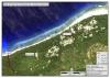
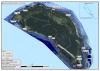
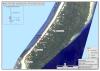
This is a SIWSAP potable water feasibility map…

Our Mission is to improve and strengthen the national institutional and administrative capacity of the division to be able to promote the protection, conservation and sustainable management of the use of the environment and natural resources of Solomon Islands
License
This dataset contains three maps SIWSAP created to assess the feasibility of wells and other potable water solutions in Solomon Islands communities.
Data and Resource
| Field | Value |
|---|---|
| Publisher | Solomon Islands Environment and Conservation Division |
| Modified | |
| Release Date | |
| Source URL | http://www.siwsap.org.sb/resources/maps.html |
| Identifier | 975efe0e-79a7-4ca4-96ab-ba95801ca82d |
| Spatial / Geographical Coverage Location | Solomon Islands |
| Relevant Countries | Solomon Islands |
| Language | English (Australia) |
| License |
SPREP Public Licence
![[Open Data]](https://assets.okfn.org/images/ok_buttons/od_80x15_blue.png)
|
| Author | Solomon Islands Water Sector Adaptation Project |